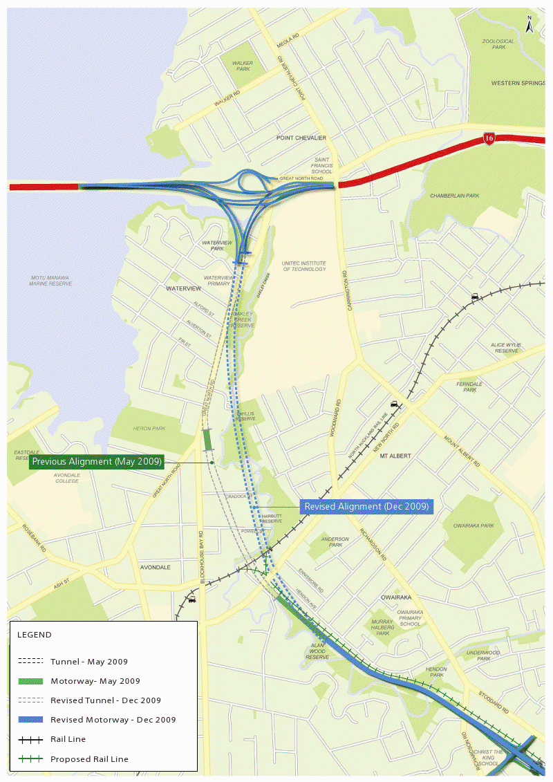
SH20 Plan Changed: Tunnel Longer & Deeper, Fewer Houses Needed (+ Map)
Final alignment changes have been made to the SH20 plan:
- The route has been shortened
- The tunnelled section will be deeper and longer
- Fewer homes will be demolished than first planned (205 compared to the 365 thought)
- Disruption to residents and commuters on Great North Road will be reduced
- Plan for central interchange at New North Road dropped
- Alignment change means 60 properties are now affected that weren’t before
- Pedestrian and cycle bridges planned that will better connect local reserves
- Building the tunnels further east without a gap can be completed within budget
- Construction starts mid to late 2011
The tunnels will be continuous from where they go underground in Alan Wood Reserve to where they rise to the surface to meet SH16 at Waterview Park.
It will eliminate the previous gap between the two tunnelled sections.
The NZTA says keeping the tunnels deeper means they can be extended further north which significantly reduces disruption on Great North Rd. Only a short length of surface construction will be required to allow the tunnel to cross underneath.
And that final alignment for SH20 from Mt Roskill to the Northwestern Motorway will see fewer homes demolished than first planned - 205 compared to the 365 estimated in May when the combined surface tunnel option was announced.
Building the tunnels further east without a gap between them can be completed within the original project budget.
The NZTA says the design improvements for the Waterview Connection section of Auckland’s Western Ring Route will also significantly reduce disruption to residents and commuters on Great North Road.
Of the 205 homes affected , 140 are already owned by NZTA. Of the 65 residential properties still to be acquired 27 are newly affected, because of the revised alignment and resulting revisions to the rail designation in the Alan Wood Reserve area.
Only three of these houses will need to be removed when the corridor is developed, with the remainder requiring partial land purchase from the rear of the section.
And the need to purchase underground land from residential properties above the tunnels reduces slightly from 111 to 105.
But the changes to the alignment mean that about 60 of these properties are newly affected.
NZTA has decided against including a central interchange at New North Road because it would contravene accepted safety standards for traffic merging, remove more housing and open space and increase traffic through Avondale.
The NZTA is working with Auckland City to replace council land required for the project and upgrade facilities to allow for increased use.
Improved linkages for the community are also planned through pedestrian and cycle bridges that will better connect local reserves.

Construction on the project is likely to start in mid to late 2011 with an anticipated completion date in the 2015/16 financial year.


3 Comments
awesome! there will be less conflict, and all the same within the budget!
I was against the last concept but now thanks to the new one im for it again.
As long as all that blue dotted line is a bored/driven tunnel then this is definitely an improvement.
Can’t work out how people from Pt Chev get onto the new motorway… seems they have to drive back to Western Springs if they want to use it.