
Wgtn Meets Its Waterloo Waterview
An important day for Wellington.
Today NZTA released details of the improvements planned between Cobham Drive and Buckle Street, and are a key part of the NZTA Ngauranga to Airport Corridor Plan.
It includes a $75m Basin Reserve flyover.

NZTA's preferred option |NZTA
Labour MP Grant Robertson says the proposal will significantly alter the landscape of our city.
“This is not just about traffic flows, it is also about the way we want Wellington to develop. And it is about the look and feel of the city we and our families will live in for future decades.”
Wellington folk have eight weeks to get their views in about the next controversial step forward in a so-called RONS Road of National Significance - BTW I so hate that term: Why can’t we have RLONS Rail lines of National Significance.? Of course, National doesn’t see any rail lines as being of any significance LOL!
The proposals include:
- Two options for a bridge to the north of the Basin to improve traffic flows and reduce journey times for public transport
- A second Mt Victoria Tunnel
- Widening Ruahine Street and Wellington Road
- A dedicated pedestrian and cycling facility between Cobham Drive and the Basin Reserve.
NZTA Regional Director Central Jenny Chetwynd argued that this will “reduce congestion, free up the Basin Reserve and other roads for better public transport, and provide a continuous, dedicated and safer link for pedestrians and cyclists between Cobham Drive and Buckle Street.”
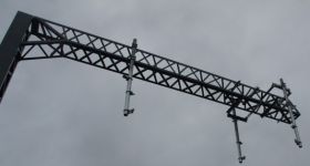
NZTA investigated several options for building a second Mt Victoria Tunnel, including replacing the existing tunnel with a wider one and building a separate two-lane tunnel.
It has decided to build a second tunnel immediately to the north of the existing one. This location was considered during the Corridor Plan’s development and in studies undertaken in the 1970s.
The new tunnel will be 700 metres long and provide two lanes for eastbound traffic. It will also provide a four metre wide path for pedestrians and cyclists. The existing tunnel will provide two lanes for westbound traffic.
It’s proposed that both tunnels will discharge fumes through the portals, avoiding the need for ventilation stacks on Mt Victoria. The speed limit in both tunnels will be 60 kph.

Mt Vic tunnel | NZTA
The issue around Basin Reserve is especially an emotive one for the Capital.
The proposals include a new Mount Victoria Tunnel, the widening of Ruahine Street, and a dedicated cycle facility from Cobham Drive to the Basin Reserve. The widening of Ruahine Street and Wellington Road will require some encroachment into the Town Belt, and Ms Chetwynd says the NZTA plans to provide adjoining land to the Town Belt to offset this.
“We understand the value of the Basin Reserve and the Town Belt to Wellingtonians and we are committed to working closely with councils and communities to ensure that we mitigate the impacts of these proposals on Wellington’s environment and heritage.
“The Basin Reserve is a major bottleneck, where numerous streams of traffic from different directions compete to use a very constrained road space. We’ve proposed a new bridge to separate traffic, which will help to free up road space for public transport priority measures and improve safety for pedestrians and cyclists who use this area.”
The street system around the Basin Reserve functions as a large roundabout with signals. About 25,000 vehicles enter from Kent Terrace each day, with nearly 20,000 heading towards Mt Victoria Tunnel. About 20,000 vehicles enter the system from Mt Victoria Tunnel, and 30,000 vehicles travel along Sussex Street.
The streets in this area have several functions, including a state highway, a local road and a key public transport route. Many people walk through the area, particularly school students.
NZTA says the streets are congested and this affects SH1 traffic, local traffic and pedestrians. It also affects bus timetables, and in the longer term will affect the journey times and reliability of a high-quality public transport system (possibly light rail) between the Railway Station and Newtown.
The aim is for the north-south traffic flows need to be separated from the east-west flows around the Basin Reserve.
NZTA’s solution is that SH1 westbound traffic needs to go onto a bridge to the north of the Basin Reserve.
It sees two options for the location of this bridge: one near the Basin Reserve; and one farther away from it. Its preference but not a final decision is one near to the Basin Reserve and add a pedestrian and cycle facility to the bridge, which would cost about $8 million.
“We considered building a tunnel around the Basin Reserve. However, because it had to extend between Paterson and Taranaki Streets to be viable, it would have been significantly more expensive to build than a bridge. The tunnel construction would also have been difficult given the need to build it in an old swamp.
“We also considered street-level options. However, while they were cheaper than a bridge they provided fewer benefits and were not as good as a bridge in separating SH1 traffic from local traffic, particularly buses and possible light rail.”
NZTA argues it will also help public transport to operate more efficiently, “making journey times shorter and more reliable, potentially enabling more trips to be taken in a day. It will also reduce vehicle operating costs such as fuel, electricity and maintenance, will help to prevent crashes, will help to reduce emissions, and will accommodate urban intensification, which ultimately means more passengers per bus stop.”
To the question: “Why not just improve public transport and walking and cycling facilities, rather than building more roads?” NZTA gives this explanation:
“Wellingtonians walk, cycle and take the bus more than people in any other main centre, and so we recognise that it’s critical we provide for all transport choices.
We want to improve people’s transport choices, not limit them. The Cobham Drive to Buckle Street improvements will make getting around Wellington easier and safer for everyone, whether on foot, on a bike, in a bus, or behind the wheel.
These proposals will help to improve public transport, pedestrians and cyclists. But to grow Wellington’s economy, we also need to provide an efficient, safe route for private vehicles – shopping trips, courier and freight deliveries, and journeys to and from the airport are all important to our economy.
“By improving the efficiency of transport between the Airport and the CBD, these improvements will also freeing up a highly constrained and inefficient freight corridor, which will reduce the cost of transporting goods and unlock efficiency and productivity benefits for the lower North Island.
Public transport in Wellington is not as effective as it could be. Bus travel in particular is constrained by traffic congestion in the city. This lack of capacity is holding back the development of public transport priority measures and dedicated walking and cycling facilities.”
These improvements will provide a long-term solution to this capacity problem, relieving congestion for private motor vehicles and at the same time unlocking new capacity for public transport and enabling the provision of better walking and cycling facilities.
Improving the attractiveness of public transport must be a precursor to modal shift, i.e. giving people a reason to get out of their cars and hop on a bus. To make public transport more attractive, it must be seen as an efficient and effective alternative to private vehicles. To do this we need to free up suburban roads to provide road space for public transport to move more efficiently.
These proposed improvements are just part of the Ngauranga to Airport Corridor Plan, which is a broader package of measures that will improve transport in the city by improving inner city traffic flows, facilitating the council’s existing and future public transport systems and improving walking and cycling facilities in the city. We are working very closely with WCC and GWRC to progress these measures to ensure all modes of transport are improved across the city.
Construction of improvements around the Basin Reserve is scheduled to start in 2014 or 2015, which is consistent with the expectations set out in the Ngauranga to Airport Corridor Plan. The improvements are likely to take two or three years to complete. The interim improvements to the Inner City Bypass and Ruahine Street may also start at this time.
The second Mt Victoria Tunnel and the main improvements to Ruahine Street and Wellington Road are currently scheduled to follow the completion of the Kapiti Expressway and the Transmission Gully sections of the Wellington Northern Corridor Road of National Significance programme.
To the question: Why are you building more capacity for state highways when traffic numbers on SH1 aren’t soaring? NZTA replies:
“Traffic numbers on Paterson Street and Ruahine Street are continuing to rise by 1% per year. This rise is relatively modest because the route is already at capacity and spillover traffic is increasingly using alternative routes such as Evans Bay Parade and Adelaide Road / Constable Street to avoid the bottleneck.
As a result, traffic growth is higher on these roads and travel times are deteriorating. On Oriental and Evans Bay Parades, traffic numbers have doubled in recent years, which could threaten its perception as an idyllic and scenic route that is safe and user friendly for pedestrians and cyclists.”
The Wellington Employers’ Chamber of Commerce in a statement says: “It is disappointing a tunnel option under the Basin has been shown not to be feasible but we are pleased with the effort to minimise the visual impact of the bridge. In order to provide certainty for everybody, decisions need to be made and construction commenced as soon as practical. We would like to see the time table brought forward if possible.”
Labour’s Grant Robertson says :“Wellington should not settle for second best. This is a huge project, and we need to do it once, and do it right. That means considering all options, even if they present some higher up-front costs.
“I am still not convinced that a flyover is the best decision. Other options, including an extra tunnel, also deserve consideration.”
There’s sure to be a mountain of feedback. Let’s hope the best decisions are made.
More on the NZTA site


12 Comments
If they do go with the flyover, I certainly hope they go with the option that takes it away from the Basin. It is a highly emotive issue and there are going to be a lot of very strong feelings about this.
Demolish the Basin! Why not? It isn’t like anything other than another big road is called for, and I don’t see why anything at all should get in its way…
Sounds like a bit of PT wash to me, they are really talking up the benefits of this road to to PT users when in reality the biggest benefits are to cars using the route. It would be different if they also planned to implement some decent PT infrastructure at the same time but it doesn’t seem like it.
Sounds a lot like banging a nail in with a sledgehammer. Why not build the second Mount Vic tunnel and see how that affects traffic before deciding whether a giant motorway is needed.
They can’t install a much needed plexiglass screen for cyclists and pedestrians in the existing tunnel because it will cost too much, yet they are prepared to do a once in a generation major fuckup (all flyovers and elevated highways in every city they are ever in have been major fuckups) to Wellington. Just how out of touch with reality are Joyce’s lapdogs at the NZTA?
Boot them out come November.
how about we just duplicate the tunnel any other 2 lane before the elevated motorway hmmm?
I’m somewhat mixed about this, not really a fan of the elevated road around the Basin, but can see what it is trying to achieve despite the likelihood of induced demand.
Not much point in a second Mt Vic tunnel without 4 laning Ruahine St and the service lane will make it easier for the person living where I’m currently at to get into the garage.
Hataitai-City traffic will be a bit of a nightmare with the removal of the right turn out of Taurima st, but far safer. Likewise at Ruahine St / Wellington Rd, the changes proposed are good for traffic heading to Newtown.
The one thing that does stand out about this for me though is the number of traffic lights on the Airport side of the tunnel, will be very stop-start!
A high-frequency light rail corridor to the airport would free up the road space by removing buses, taxis and private cars and would create its own induced-demand cycle, while requiring a fraction of the footprint for this road project.
If they are so keen on PT, why not do the second tunnel as a dedicated busway or light rail?
Blinkered.
In terms of cycling, it will be really good if they do go with the second tunnel. A 4 metre wide footpath, sealed off from traffic noise and fumes will be so much better than the horrible narrow unprotected one in the current tunnel. The dedicated cycle facility (not sure what that means exactly) between the Basin and Cobham Drive will be a massive improvement on the current provision for cyclists, which is nothing.
flyover…???? what is this 1962? there’s all of 5 people in WGTN, Joyce is so obsessed with driving to an airport, can’t he just get on a plane one day and leave… he might visit some real cities and see that most are taking flyovers down, or at least wish they could afford to.
So sad, still, as the Chinese say, ‘the coals burn brightest just before going out’……
Its just crap, they refuse to look at any other options its a flyover or a slightly longer flyover. Their statements are quite amusing too at looking at other options:
“We need to bring options that we are prepared to build and we can support. There is no use consulting on things that we don’t [support]. That would increase expectations unnecessarily.”
The thing is they could make a tunnel through buckle st and have north/south traffic rising over the top of it, their latest excuse is that its a swamp area, which the basin is, but buckle st is on a hill so that doesn’t make any sense. They’ve also said it would be too expensive, something in the order of $60 million, but their latest most expensive flyover option is $90 mil!