
Pics: Kopu Bridge Progress
")
Pile casings measuring 24m and 36m are constructed on site
The piles extend up to 55m into the bed of the Waihou River. Soils in this area are soft silts laid down by the river over thousands of years, so long piles are needed to support the weight of the bridge.
A 36m pile casing has been driven beneath the river. A 24m casing will be welded on top.
The 36m pile casing is then transported onto the temporary working platform, lifted into place and driven into the river bed using a hydraulic hammer hung off a crane. Then, if needed, another 24m of casing is welded onto the 36m casing and driven to final depth.
Each pile is then filled with a ‘pile cage’ made from reinforcing steel and lowered into the pile casing, which is then pumped full of concrete.
When each pile is complete, a reinforced concrete pile cap binds the tops of the piles together. On top of this, the pier column and pier head are then constructed.
Reinforcing steel protruding from each pile is further reinforced and concrete poured to form a pile cap that will become the foundation for a bridge pier.
Installation of underground services between the new roundabout and the Kopu Tavern have been completed.
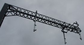
At the D&H Steel Construction factory in Auckland, the first bridge girders are being manufactured.
Monitoring continues on the embankments that have been placed along the bridge approach roads either side of the bridge. The embankments are needed to compress the soft soils underneath prior to final road construction and have to be built up slowly.
Because the subsoils under the embankments are wet and soft, there are limits to the weight they can bear. Too much weight imposed all at once can cause the subsoils to fail.
To prevent this, subsoil pressures under the embankments are regularly monitored, and extra embankment fill is only added when subsoil pressures allow. The next top-up is likely in the next 2 months.
Another year of settlement time is expected to be required for the new approach roads. Recently, repairs were carried out on sections of the state highway adjacent to the settlement embankments as adjacent settlement caused cracks to appear in the state highway. This was expected to occur and it’s likely more repairs will be needed as time goes on.
Right now:
- Construction work is continuing on the piers
- Monitoring at the new roundabout site will end soon because the results are showing that settlement will be complete next month - seven weeks earlier than expected
- Construction may begin soon on the roundabout
- Pre-assembly of the first girders is starting and, if everything goes smoothly, then soon after the girders will be erected permanently
- Some girders will be pre-assembled on the ground for later installation


14 Comments
“Monitoring continues on the embankments that have been placed along the bridge approach roads either side of the bridge. The embankments are needed to compress the soft soils underneath prior to final road construction and have to be built up slowly.”
So THAT’s what the stuff is for. I am a civil engineer and hadn’t even thought of that. It just looked so weird.
Thanks for that, Jon.
@Karl Dont blame the messenger. I’m not a civil engineer. This is an update from NZTA in their words as i made clear. If you know better or think its stating the obvious, go ahead and enlighten us.
Jon, I don’t think Karl was being sarcastic.
I’m a geotechnical engineer involved with piling, settlement issues etc - the technical detail here is pretty good for a press release I would say.
Given the issues with high tides on SH16 at the moment, I would say monitoring and ‘building out’ settlement on the SH16 widening project will be a big issue there - similar to what they are talking about here.
is this two lanes each way? fail if its one lane each way… whats happening with the old bridge?
@Carl 2 lane and old bridge won’t be demolished as it’s classified as historic by the Historic Places Trust. More details in an earlier post
http://www.aktnz.co.nz/2009/12/10/kopu-bridge-replacement-work-starts-at-last/
Jon C - I was THANKING you for your post explaining me the reason behind those piles of rock which looked too rough to be a road bed or temporary road.
I am a civil engineer but not a geotechnical engineer and could probably have driven past the site another couple dozen times without getting it.
There was no sarcasm in my post at all.
so does that mean then the old bridge will still be in use? I’m guessing the new bridge cuts through the farm land and goes straight to the turn off? where as the old bridge would be used for local traffic to thames anyone going further north that way right? hope so.
Carl - Sadly I don’t think it goes straight to the turn off, my understanding is that land is owned by the local iwi and they wouldn’t allow the road to go over it.
@ Karl All good! Thanks and cheers
The old bridge will be very unlikely to be used for motor vehicle traffic, as that would require keeping signals operating, and keeping it up to the standards required of a motor vehicle bridge.
It may end up being lightly refurbished, and then integrated into the area as a cycle / walking bridge, is what I heard as being discussed.
The old bridge I guess will be used for the national cycle route?
@Chris S The Hauraki rail trust pushed through a cycleway based on the central otago rail trial- from Paeroa to Karangahake Gorge - it includes historic gold-mining areas, then follows the river down to Waikino to the head of the vintage railway which leads into Waihi.
The Paeroa to Thames trail would follow a disused railway line with access to areas of ecological significance such as wetlands
There has been talk of using the old bridge but I havent personally seen any cost or viability assessment
Paeroa-Thames cycleway would surely be on the eastern side of the river anyway, wouldn’t it?
There was also talk of a Thames estuary cycleway, which I think could be nice - though maybe not as much to see, but great as a part of an Auckland-Thames link for cycling in the future. But that could also go over the new bridge, if preferred or needed.
Since it’s a heritage bridge, one assumes that there will be at least a minimal level of upkeep for the old bridge.
what happens to the steel cassings . do thay just rust away.please tell me