
Onehunga Platform Starts
The new Onehunga platforms are coming on.
The platform walls are completed, just waiting on back-filling.
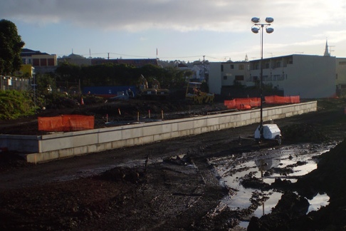
Roger Kirk who took these photos today (thanks, Roger!) got this view from west of the level crossing. This is where the curve ends and the line runs straight to the new platform.


10 Comments
Should we be concerned that the platform is only long enough for one ADL railcar?
Do they plan to reconnect to the wharfs at some stage?
I agree with Jon R… won’t they have to extend these platforms in at most 3 years when our shortest trains are 3 cars long?- or will passengers at the back be stranded till they get back to Ellerslie…
They’re currently extending the platforms at both Mt Eden AND Kingsland- they were both only done up a couple of years ago, and now half of it is being bulldosed and replaced…The costs of this continuous short sightedness must really be stacking up
It is surprising that Penrose and Te Papapa are 4-car, but Onehunga only 2-car. Probably to lower the cost as part of the rush to get it completed.
The track doesn’t go straight from the curve btw, it goes from left curve, to right curve, then straight. For some reason they have added this track kink into the design.
Er, no, it’s not surprising at all. It’s been said repeatedly that the Onehunga station is only temporary.
Good to see folks questioning the Onehunga station design - I noted some time back that Onehunga is a potential junction (Penrose-Onehunga-Airport, Onehunga-New Lynn), which meant any platform should be aligned on the side of the junction with most potential traffic. ie along Princes St, from Galway St eastwards, which is flat, straight and hugely expandable, and closest to the Dresssmart mall.
ARTA’s reasoning (such as it is) seems to be to minimise curvature (so guards can see full length of units) and get passenger trains on a siding so wharf freight can bypass ‘parked up’ units waiting for the return trip to start. Of course, there is space for a bypass track along Princes St, and between the ITM site and the wharf (in fact, the latter had 2 tracks til Ontrack ripped them out for this rebuild).
The real question is - if we ever get an Onehunga-New Lynn line, shortening the South-West trip and linking new suburbs into the rail network, how will ARTA link such a triangle of tracks? The obvious junction is at the ITM site, but their station design blocks this, making any rebuild hugely expensive….. oh, perhaps that was their aim. ;(
Meanwhile, no more cash for the rest of Auckland stations to be upgraded…
Related matter - Jon, has anyone raised the possibility of using the ‘temporary’ concrete & steel low-level bridge NZTA used for cranes to build the second SH20 harbour bridge for an extension of the Onehunga line to Mangere Bridge?.
If the engineers can tweak it to take rail axle loads, this would be a very cheap and unobtrusive way to get a rail bridgehead on the Manukau side, which takes road traffic off the bridge (though NZTA may not thank you for undermining their BCR for the 2nd motorway bridge ).
).
Mahunga Dr is an industrial zone, with 100m walk to Mangere Bridge shops, and the existing bus routes all come off the SH20 bridge at the Mahunga Dr-Rimu Rd overbridge right next to where a station would be.
Cost should be $5m for Mangere Bridge station by Te Puea Marae, $10 for the under 1km of single track, plus whatever is needed to fix up the crane bridge to permanent rail standard. Surely this is able to be done for under $30m total?
And it’s perfectly lined up for cheap progressive extensions towards the Airport, cut’n'cover tunnel under the Hastie Ave ridgeline to cross side of SH20 (which also minimises gradient) and then follow the existing grass corridor along the West of SH20 and North side of SH20A to the Airport. Stations at (possibly Walmsley Rd) and Mangere and Ihumatao and Airport.
Bob, don’t get all conspiratorial. Have you SEEN the design? It is cheap and quick. Now that may not be good in other respects - but one thing it will NOT do is be a serious hindrance to airport rail or a Southdown-Onehunga line.
It won’t even be a roadblock - it will be a twig on the tracks.
@ Karl - it’s not conspiritorial to be critical of badly flawed ‘temporary’ designs, Karl. As Sam and others noted above, this ‘twig’ of a temporary platform cuts right across the site of any natural junction with an Onehunga-New Lynn line (there is no point building an Onehunga Southdown line duplicating the one they are rebuilding now, is there?). And you ignore the disruption caused by rebuilding to yet another platform if this one is just temporary - ask West line passengers how they feel about the non-stop upgrade works and the effect on their train service…
Also, again as Sam noted, the cost of continually rebuilding these platforms is rising, and every million $ wasted on failed temporary platforms cuts out upgrades to existing platforms like Greenlane.
Time for some common sense - and doesn’t anyone have anything to say about my proposal that we use the ‘temporary’ SH20 construction bridge as a rail bridge to Mangere? It is perfectly aligned and at the correct level and lines up with the land corridor for rail on the other side. Get it now before NZTA demolish it, and we have to spend tens of millions more building from scratch.
Bob - the problem is you want the train station as close to town as possible so it is actually useful for people and it needs to be in an area with releativly high visibility for safety. You also can’t have a station on a curve that sharp so it needs to be on a fairly straight section of track. With the existing designation it meant that the station would have either had to have had to have been on the straight section east of Galway St or south of Neilson St. Both locations are not ideal for passengers and don’t give a very good connectivity to the town centre or allow for a good interchange with things like buses etc. As a result patronage would be fairly poor and the line would likely be up for closure again in a few years.
If we are going to build a line to the airport we are not going to be able to use that existing designation anyway due to station location issues I just mentioned so it I don’t really see the current station as much of a problem.
As for the Southdown Avonldale line (SAL). If you look closely there are already tracks that come all the way up to Neilson St, about 370m south of Church St. There is also an existing designation that travels almost directly west of here all the way to Captain Springs Reserve where it meets the existing Onehunga Branch. It shouldn’t be to hard to hook those up if needed. The original intention of the line was for freight to be able to bypass the city.
As for the temporary bridge, at best it might be able to carry one line across the harbour but to modify it would likely cost the same or at least similar as doing it properly. As a city and country we need to stop the half arsed attempts at things and do them right.
My personal preference for lines through here is to sink a trench down Princess St and put the rail line in that. It could then split in a junction with one set of lines heading south to the bridge with the other out to SH20 to head north to Hillsborough.