
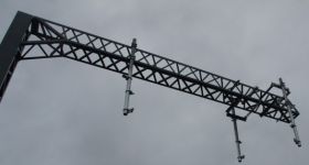
New Electronic Motorway Signs
 From Monday, watch out for the first of 250 electronic message signs will be progressively commissioned on the approaches to Auckland motorway on-ramps .
They will show estimated journey times in minutes for travel to a destination via a motorway.
The electronic signs will display three key destinations and the estimated time it takes to reach them.
Travel information will be updated regularly as traffic conditions on the motorways change.
The system is designed to provide estimates that, for a typical 25 minute trip, will be within four minutes of actual journey times.
The first signs will be switched on in the city bound direction at:
- Oteha Valley Road (Northern Motorway)
- Princes Street
- Highbrook Drive
- Takanini
- Papakura (Southern Motorway)
- Te Atatu Road
- Lincoln Road (Northwestern Motorway).
They will initially be turned on during the middle periods of the day, and their hours progressively extended as more of the system is commissioned.
The signs are part of a series of new motorway management and traveller information initiatives by the NZTA to provide motorists with more information to plan their journeys and improve traffic flows arouond Auckland.
Other initiatives already operating on the motorway network include the series of managed priority lanes, lane control signals and ramp signals.
NZTA’s Tommy Parker said the four minute estimate journey time would be based on the best available information and normal motorway conditions, and added that motorway incidents could impact on journey times.
The signs can also be used to alert motorists if there is an incident or congestion on the motorway, and provide information for drivers about an alternative on-ramp or local road if they chose.

Signs will be controlled from NZTA's new centre which opened Friday
The signs work by gathering data from detectors and loops under the road as well as individual waiting times at each on-ramp. The information calculates the average speed of vehicles, which is then used to determine expected journey time to each destination.
The travel time signs will be operated from the NZTA’s new Traffic Operations Centre at Smales Farm in Takapuna, which was officially commissioned on Friday.


4 Comments
How about real time passenger information on trains?
Filed under: ‘polishing a turd’…
Linking the information on these signs into the NZTA Traffic website would be a nice touch…
I’d add 10 minuties on the signs to discourage the road users when the city’s new train system is in use.