
Footbridge Across Harbour Bridge Update
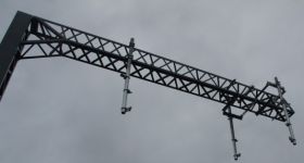
After posting photos of how the footbridge over the Auckland Harbour Bridge SH1 motorway near Fanshawe St is looking like as it’s being built, some have been critical.
So NZTA have kindly given me the designs so we can see how it should look when finished.(Thanks NZTA)

And here is how it looks today before you can walk across:

The design resembles a traditional Maori fishing net. The draped fish netting design is a reference to the area’s historical importance to Maori as a fishing ground.
Now here are more of the designs for the finished bridge:


So we can get a better idea of how it will be than it is today:

The 102 metre-long covered footbridge reconnects the St Marys Bay residential area with the Waitemata Harbour over the SH1 motorway in St Marys Bay as part of the Victoria Park Tunnel project.
The bridge will be fully covered with acrylic panels.

Principal architect, John Coop, calls it a simple, bold and sculptural form… “appropriate to its location – a gateway to Auckland – yet we have also aimed to be sensitive to the community living nearby and to the natural environment.”
The seaward end of the new bridge will be linked to Westhaven Drive by a staircase and a lift. At this end, there will be a viewing platform to the harbour.
The design of the bridge is a collaborative effort by architects SKM and Warren and Mahoney, landscape architects Boffa Miskell, a Maori design company, Kupenga Design, and the partners in the Victoria Park Tunnel alliance.
At its landward end, the footbridge connects to the Jacobs Ladder staircase, originally built in the 1880s to provide access down the cliffs, and to the new walkway beside the motorway through St Marys Bay.
It is a walkway that seems little known outside its area and is hidden at the end of a no exit residential street (Waitemata St) near the Catholic St Mary’s School.
It used to be a very dangerous looking old walkway that felt as if you were extreme sport-climbing down the cliff and was accompanied by council warning signs that it was steep - too steep for some of the older residents who have lived in the area for years.
This is what it looked like:

Jacobs Ladder in St Marys Bay before it closed
It has been rebuilt by NZTA as part of the extras being offered as part of the Victoria Tunnel Project and has been warmly welcomed by locals.
It was pleasing to see some elderly people manage the climb while I was taking these photos.


It means you can now walk to Victoria Park instead of just walking to the bottom and confronting the motorway with nowhere to go.
The area is no longer isolated from the city. Connecting up the dots to the waterfront is one of the key missions of the Auckland Plan and this is another little example of what is possible.

The old steep walkway went down the cliffs at St Mary’s Bay to the historic foreshore before the motorway arrived.

The ladder was historically, the only access to St Mary’s Bay, which was an early Auckland ship builders’ place, with small vessels secured to the wharf. A few decades ago, there was still a small navy building in a tiny reserve that was at the bottom of the ladder.


In 1925, HMNZS Ngapona was formed and used for training purposes until the harbour bridge was built.
Putting the bridge approaches there left the building and naval boats high and dry, as it was now alongside a motorway.
Ngapona closed last year and the naval people involved relocated to the Devonport base.


11 Comments
That stairway now looks like it was inspired by a prison.
“It means you can now walk to Victoria Park instead of just walking to the bottom and confronting the motorway with nowhere to go”
This is untrue, the pre-existing walkway also connected to Victoria Park, albeit through a dodgy, overgrown path…
Matt, standard vandal-proof design… there’s worse around in Auckland. The bridge at least is looking really great, though would have loved a cycle ramp at the northern end. For now we will have to use the elevators…
Yeah, why so much metal and fencing everywhere. For all the beautification the area is really a (now even bigger) motorway onramp where you are unlikely to linger.
Would have been nice if they had added a sort of rail/gutter along the stairs so you can push a bike up and down. But good to see this project nearly complete.
I hope they’ve figured out a way to stop the acrylic panels becoming covered with graffiti
Cornelius - we (Cycle Action Auckland) did actually ask for a cycle push ramp in discussions with the project team. They eventually came back and said they considered that as not feasible. Probably they felt it was too narrow & steep - they didn’t really give much of an explanation, I am afraid.
It still looks like the the structure a hundred meters or so west that carries the green motorway lane signs-
But it’s a hell of a lot better than the original design- a giant distended intestine hanging above SH1.
B- at this stage, let’s give a final grade when the panels are on?
“I hope they’ve figured out a way to stop the acrylic panels becoming covered with graffiti”
Well, they built it in St Mary’s Bay.
I like the look of that old Jacob’s Ladder, I like the narrow wooden rickety staircase. As I’ve said previously, the new one is about as exciting as my apartment building’s emergency stairway.
Looking forward to the walk up to Point Erin Park. I assume you can ride it, and it’d be safer than cycling on Westhaven Drive when the SUVs are rat-running.
tBird - I understand the new path west from the bridge to Point Erin Park was ON PURPOSE kept narrow to discourage cyclists, because the locals hated the idea. May just be a rumour, but it would be a perfectly normal NIMBY response.
At least we will be able to use Jacob’s ladder bridge.
Looking at the first pic it would seem that there are gaps to the sky facing glass and the joints…hope they’re not gonna be in the finished bridge otherwise we’ll get wet…
Is this one of John Key’s cycle paths?
Oh no, how silly of me, it’s just a workaround for one of Steven Joyce’s Roads of National Impotence.