AMETI Open Day: Scheme Details
AMETI has been a mystery for me until recently.
It’s been lurking around the Auckland transport schemes for years emerging rarely in a transport committee agenda only to disappear while more consultants pour over it.
The name always put me off. It sounds like some fancy men’s fashion label, expensive sports car or toothpaste.
A tweet pointed out JAWS, the movie was set in Amity Island!
I was also always suspicious that it was the new disguised brand name for what had been Banks unpopular Eastern Highway scheme. To be frank, they should ditch the name with all its bad smell about it and come up with a name that easily makes sense for the region.
I mean even now it’s hard to get excited about or vigorously debate something called AMETI Road Through Covered Box!
But the region it is about is crying out for better traffic management and some decent public transport - in fact it’s an area criminally neglected when it comes to developing PT.
So I am glad Auckland Transport has grabbed it, is pushing it through and is explaining more easily to ignorant people like me what is actually planned and when.
AT is holding an open day today to explain the plan to residents.
So we can all grasp the basics, here is what they are being told:
————-
The Auckland Manukau Eastern Transport Initiative (AMETI) is a group of transport projects for the eastern suburbs. The aim is to give people living in the area transport choices by improving public transport, walking and cycling facilities and reducing traffic congestion.
Other major aims are to unlock the economic potential of the area and to promote good urban design.
The need:
Severe congestion in the area is holding back the huge potential for economic growth in the area – there are a number of sites ripe for redevelopment if key transport links are improved. There is potential for 40,000 new jobs in the area.
Public transport use is very low, less than four cent of all journeys, because it isn’t a realistic travel choice people have to drive.
The population is also expected to grow by 20-25,000 during the next 20 years, further increasing pressure on the transport system.
The plans:
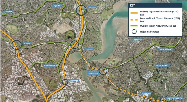
- AMETI will see a major focus on public transport improvements, including a busway with high frequency services that will eventually run between Botany, Pakuranga and Panmure
- Getting more people onto public transport will free up roads for freight and business traffic. A number of roading improvements will ensure roads work effectively
- Local journeys and public transport will be focused on the Panmure Bridge route
- The Waipuna Bridge and south eastern highway will become the primary route for through traffic to Auckland central and freight/ business traffic
AMETI Panmure
Timing Construction: 2011 - 2014
Status: Proceeding to final design and consenting
- AMETI road
- Mountain Road diversion
- E-P Highway lifting
- E-P Highway busway bridge
- Covered Box for rail and new AMETI road
- Local road over covered box
- Replace footbridge over rail between Ireland Road and William Harvey Place
Construction: 2014 - 2016
Status: Still at concept stage. Opportunity for feedback will be at a later date
- Panmure Roundabout replacement
- Lagoon Drive Bus Priority
Construction: 2015+
Status: Still at consent stage. Opportunity for feedback will be at a later date
- AMETI road extension
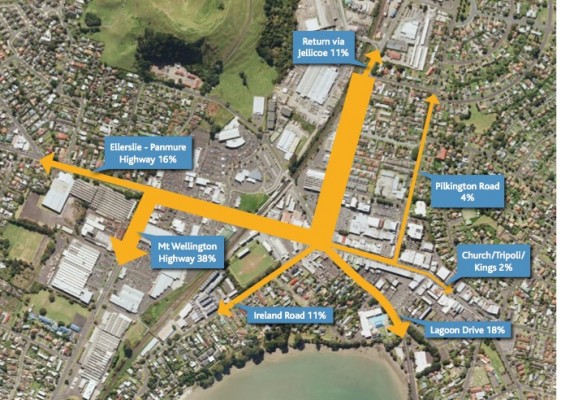
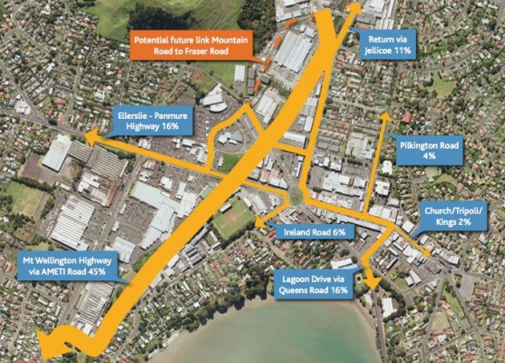
Changes to Traffic Movements from Jellicoe Road Following Roundabout Replacement
Existing
- Currently 38% of southbound Jellicoe Road traffic is destined for Mt Wellington Highway, 18% to Lagoon Drive and 16% to E-P Highway.
- 11% is destined for Ireland Road (much of this is rat running to Carbine Road).
- 11% go back up Jellicoe Road, presumably after visiting Panmure town centre.
Future
- 45% of current southbound Jellicoe Road traffic will divert to the new AMETI link, including some trips currently using Ireland Road and Lagoon Drive. Traffic headed to E-P Highway will use Mountain Road / Forge Way, or divert elsewhere (eg Lunn Ave).
- Some of the traffic using Ireland Road (rat run) and Lagoon Drive (to Pakuranga / Botany) is likely to divert to the AMETI Road and Mt Wellington Highway.
Designation Outlines
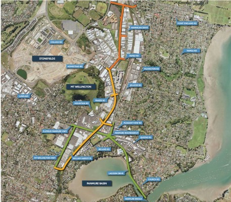
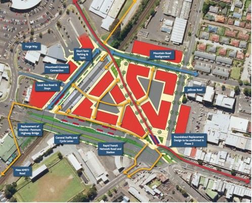
Realignment of Mountain Road and Ellerslie Panmure Highway (Phase 1a)
Auckland Transport will submit a Notice of Requirement to Auckland Council in April 2011 of its requirement for a designation in the Auckland City District Plan: Isthmus Section for public works in the vicinity of Mountain Road, Mountwell Crescent, Forge Way, Ellerslie Panmure Highway, and Jellicoe Road.
Statutory approvals will also be required for
- The proposed Park and Ride Facility at 528 536 Ellerslie Panmure Highway (Auckland Transport)
- The proposed upgrades to Panmure Station (Auckland Transport).
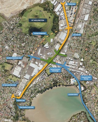
AMETI Link Road - Mt Wellington Highway to Tainui Road (Phase 1)
Auckland Transport intend to submit a Notice of Requirement to Auckland Council in August 2011 of its requirement for a designation in the Auckland City District Plan: Isthmus Section for public works for the AMETI Link Road between Mt Wellington Highway (Triangle Road) to Tainui Road.
Construction of the new road linking Mt Wellington Highway and Morrin Road will remove some through traffic from the town centre and will serve proposed developments to the north of Panmure. Construction is expected to start in 2012.
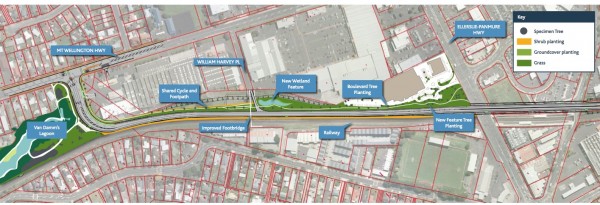
This designation will include mitigation proposals to off-set the impact of the proposal on Van Damm’s Lagoon.
Ellerslie Panmure Highway to Panmure Bridge (Phase 2)
This next stage is currently at concept stage. Detailed design will begin later this year. Statutory approvals will be sought in 2012.
AMETI Road (North)
The proposal is for a new two lane road from Morrin Road in the north to Mt Wellington Highway in the south
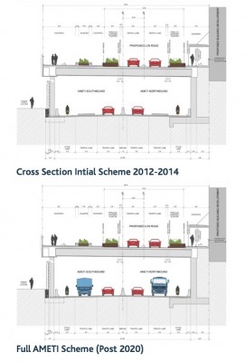
- Long term proposal is to make it four lanes (post 2020)
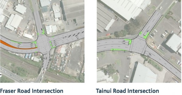
- Morrin Road to be widened to four lanes between Fraser and Tainui
- Improved vehicle access
- Safe pedestrian and cycle facilities
- Boulevard style large tree plantings
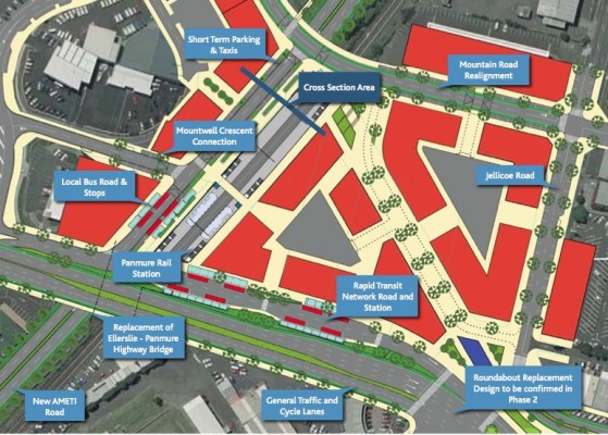
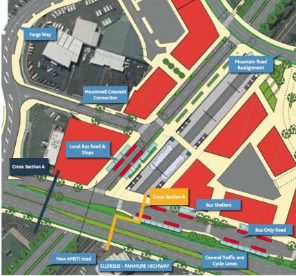
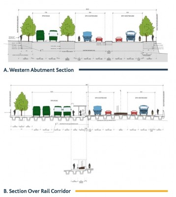
AMETI Road Through Covered Box
- Between Mountain Road and Ellerslie-Panmure Highway the new road will be covered
- Another road will be built on top, for local buses and providing access to the station for drop off and taxis
- Mountwell Crescent will be realigned to connect with the new road
AMETI Road (South)
- New road extended to meet Mt Wellington Highway near Triangle Road
- Initial two lane scheme has limited impact on Van Damm’s Lagoon • Footbridge between Ireland Road and William Harvey Place to be replaced with wider longer bridge with disabled access ramps
- Left turn from William Harvey Place onto the new road provided
Panmure Interchange
Updated intersection/bus/rail station plan showing pedestrian connections
- Pedestrian connections around the station will be improved
- Interchange between buses and rail will be enhanced
- Development of the proposed Transit Orientated Development (TOD) will be enabled
Phase 2: On Going Urban Busway Investigation
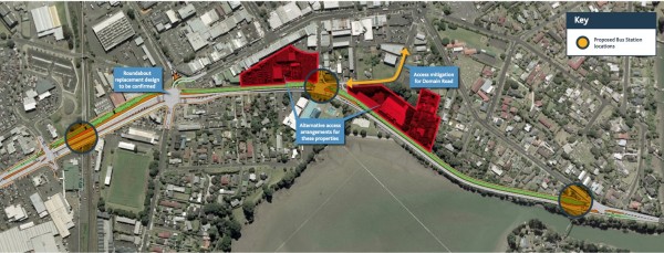
To accommodate the urban busway, access arrangements to a number of properties will need to be modified. The project team are currently identifying issues and preparing options for discussion with land owners.
Panmure Bridge
The team are assessing options to widen Panmure Bridge to generate continuous busway priority between Panmure and Pakuranga.
* If anyone wants this as a PDF to see things clearer just drop me a line at aucklandtrains at gmail dot com subject line PDF




1 Comments
Thanks for the post….this is beginning to make sense now…