
Panmure Transport Plans
An Auckland City open day is to be held to show what’s ahead for transport in Panmure.
The changes are part of the Auckland Manukau Eastern Transport Initiative – a series of transport improvements designed to cater for population growth in the east of our city and improve traffic flow and access around the area.
The planned improvements will enhance connectivity between Glen Innes, Panmure, Mt Wellington and Sylvia Park in Auckland city – and Pakuranga, Flat Bush and East Tamaki in Manukau city. They will make public transport, walking and cycling better choices for getting around.
Panmure is the first of six stages to go ahead. The next step for this stage involves completing the detailed design and consenting work for the corridor from Panmure Bridge to Panmure Town Centre and through to Merton Road.

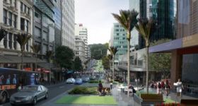
Panmure in the future? |AMETI
The improvements planned for the Panmure stage include:
- walking and cycling improvements for Panmure Bridge
- bus priority along Lagoon Drive to an interchange at Panmure Station
- a new signalised intersection at Panmure roundabout to improve safety
- traffic flow and pedestrian crossings
- the realignment of Mountain Road between the rail bridge and Jellicoe Road a new road linking Mt Wellington Highway and Morrin Road (and later, Merton Road).
When: Saturday, 29 May 2010, 10am to 3pm
Where: Panmure Community Hall, 7–13 Pilkington Road, Panmure
There will be two presentations from members of the project team – at 10.30am and 1pm.
The open day will feature technical and visual displays and the opportunity for people to discuss the project with members of the project team.
AMETI website www.ameti.co.nz/


6 Comments
A feeder express running from Botany, Howick, Highland park stopping at a hub in Pakuranga then to Panmure train station in dedicated bus lanes would be perfect.
As JArbury has noted - bus lanes do not good PT make. The area to the east of Panmure (which AMEIT is to improve connectivity to, after all) are a wasteland for PT, and doctoring around the edges of that while building massive new roading infrastructure is not going to fix the car dependency.
Which is so STUPID. Why would you want more and more and more cars going through all the residential areas that span the alignment from the CBD to Howick? It’s like building an open sewer through your backyard because you are too cheap or set in your ways to look into this “pipe” stuff.
I’m not sure bus lanes are too bad…as long as they’re wide enough for buses to safely travel at 50 beside congested traffic, they should offer significant time savings (I am assuming that traffic is congested through this road at peak??), as they do go right up to the traffic lights in the image, rather than merging with the other traffic at major intersections as they do in many areas, such as Dominion Road. Dominion Roads bus lanes do offer pretty good time savings at peak, and I think thats what entices a lot of its users out of cars, despite the lanes not really having either of the properties I’ve mentioned above. I think its also crucial that the lanes operate for much more than 2 hours per day though.
Overall, I think busways and especially rail is the answer, but this should be a big improvement over the current arrangement, especially if there is good integration at Pamnure station, i.e timetables that match up, integrated ticketing, bus stops AT the station, and some pretty apparent advertising of the transfer.
One thing that concerns me about the picture above though… what is that structure in the bottom left- its not a parking building is it?
You mean the bottom right? I’d ASSUME you need not worry about it - AMETTI wouldn’t be in the business of building design or making calls on what goes where on private land - but the guy drawing up the nice pictures had to make SOME call on how the area would look like in the future.
Bus lanes are fine, the point is that ARTA’s plans have a rapid-transit line running through Panmure. Where is that line in these plans???????
I just saw that there is an open day about Ameti on the 16th of October on http://www.ameti.co.nz:
“AMETI info session to focus on PanmureThe Auckland-Manukau Eastern Transport Initiative (AMETI) will hold an information session on Saturday, 16 October.
AMETI is a series of transport projects in east Auckland to cater for the city’s growing population and improve transport options for pedestrians, cyclists, motorists, freight movement and passengers on public transport.
Drop in to Panmure Community Hall, 7-13 Pilkington Road, anytime between 10am and 1pm to find out more.
There will be information available about:
- Panmure intersection proposals (roundabout replacement)
- The new bus rail interchange
- The Lagoon Drive busway concept
- Mountain Road to Fraser Road link investigations
There will also be a 30-minute presentation starting at 10.30am.
The Auckland Manukau Eastern Transport Initiative (AMETI) is a regional priority, jointly managed by Auckland and Manukau city councils and ARTA.”